Kanu Links
![]()
The Spanish River
under threat from the Lands for Life proposal of Oct 30, 1998
![]()
The following information has been superseded by the Ontario's Living Legend proposal, and the information on this page is kept for auditing purposes only
![]()
In the province of Ontario, thirty-nine million hectares of public land, about half the province, will be divided between industrial interests such as timber, mining and hydro, tourism interests such as hunting, fishing and canoeing, and conservation interests. The Spanish River area is included in this resource allocation effort called Lands for Life.
| East Branch (Duke Lake to Forks) and West Branch (Lake Biscotasi to Forks): are designated as "Heritage Waterway" surrounded by "General Use Area" and are afforded no protection at all. All this area can be logged and mined, the woods will be carved up by roads and ATV trails, and motorized craft can freely dominate the waters. Only the building of new cottages along the river is curtailed. Spanish River, Forks to Agnew Lake: |
|
| It is a wilderness that the Disney corporation could be proud of: a curtain of forest along the river, some conservation enclaves in the hills and the rest of the land open for forest operation, mining, road building and cottage development. |
| * Nothing in the report acknowledges this area as a major canoe route. How could they miss this? |
![]()
write or e-mail!
* ask that ALL the river is designated as park, not just the river below
the forks, but also: the East and West Branches, and the Side Trip Route (that leads
through Lake Pogomasing, Kennedy Lake, Bluewater Lake and the Mogo River)
* insist that the park extends beyond the narrow shore strip to include large areas of the valley, such as the proposed Spanish River Valley Old Pine Park
|
(lflcomment@webmail.mnr.gov.on.ca) |
Hon Mike Harris Premier of Ontario Legislature Building, Queen's Park Toronto ON M7A 1W3 Fax: (416) 325-3745 Tel: (416) 325-1941 |
![]() E.B.Eddy's Logging
Plans, click here! (Large map, will take about 3 min's to download on a
28.8KB connection)
E.B.Eddy's Logging
Plans, click here! (Large map, will take about 3 min's to download on a
28.8KB connection)
Details of The Lands for Life Plan for the Spanish:
The immediate river is designated Heritage Waterway
(i.e. the waterway itself, plus lands 200 metres (m) inland from shore.)
| Commercial resource uses permitted: | Commercial resource uses permitted under special conditions: | Commercial resource uses not permitted: | Recreational uses ... | Roads: |
| Fishing, commercial and bait Tourism operations Fur and wild rice harvesting |
Aggregate extraction allowed without special conditions. [BE] All forest management operations subject to special resource management guidelines. [BE] New hydro allowed without special conditions. [BE] Mining, including mineral exploration: |
encouraged: Angling Hunting Snowmobile and all-terrain vehicle use Existing seasonal residences and recreation camps No mention of Canoeing....
Recreational uses not permitted: |
Existing and new roads allowed where
compatible with waterway values. Road planning and design subject to special guidelines compatible with waterway values. Primary and secondary roads limited to recreational access and essential crossings. Public road use encouraged where compatible with waterway values. |
The land 200m beyond the shore is designated as General Use Area:
| Recreational uses encouraged: | Recreational uses encouraged under special conditions: | Commercial resource uses permitted | Roads: |
| Angling Hunting Snowmobile and all-terrain vehicle use |
Seasonal residences and recreation camps: Allowed where compatible with area values. Existing seasonal residences and camps allowed to stay. [BE] |
Aggregate extraction, Fishing,
commercial and bait Forest management, including timber harvesting New hydro power development Mining, including mineral exploration Tourism operations Fur and wild rice harvesting |
Existing and new roads allowed. Public road use encouraged where compatible with area values. |
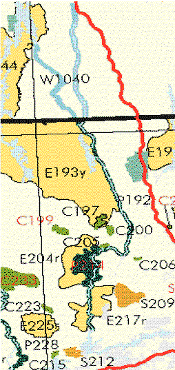
| The river itself is proposed as a park (P192), at a length of 86km and an area of 4010 hectares. This makes it a strip of land, extending about 200m on each side of the river. | |
| Another park: (Spanish River Valley Old Pine, P124) has a designation of "special study area - decision deferred", and I am not sure what that means. It is on river-right of the Spanish, past the Graveyard Rapids, and covers an area of 4932 hectares, about 7km times 7 km large. | |
| Conservation Areas: (C197, C199, C200, C205 and C206) are quite away from the river and small (together 2751 hectares). And mineral exploration will be permitted, and consequentially some road access. ("Recommended change: Allow mineral exploration where compatible with reserve values. Permit exploration through an exploratory licence of occupation, where the proponent may proceed to mining only if compatible and under special conditions. Control exploration activities through special work permit conditions. [GLSL] " |
There are other areas with a special designation. This designation does not afford protection from logging, mining nor digging of gravel pits: S209 is a "Stewartship Reserve", E1044n ("Natual Heritage"), E217r and E204r ("Remote Access Enhanced Management"). Here are the details of these designations:
| Stewartship reserves:(S209) |
| Commercial resource uses permitted: | Commercial resource uses permitted under special conditions: | Commercial resource uses not permitted: | Recreational uses encouraged: | Roads: |
| Fishing, commercial and bait Tourism operations Fur and wild rice harvesting |
Aggregate extraction: Allowed where
compatible with reserve values. Operations subject to special resource management guidelines. |
New hydro power development
|
Angling Hunting Snowmobile and all-terrain vehicle use allowed where compatible with reserve values. [GLSL] Recreational uses encouraged under special conditions: Seasonal residences and recreation camps: Allowed where compatible with reserve values. Existing seasonal residences and camps allowed to stay. [BE] |
Existing and new roads allowed
where compatible with reserve values. Road planning and design subject to special
guidelines compatible with reserve values. Public road use encouraged where compatible with reserve values. Existing public road use may continue. [GLSL] |
| Both forest management and mining allowed where compatible with reserve values. [GLSL] | ||||
| Mining, including mineral exploration:
Either forest management or mining allowed in a reserve, but not both. Exploration activities controlled through special work permit conditions. In some cases, exploration may be permitted through an exploratory licence of occupation, where the proponent may proceed to mining only if compatible and under special conditions. |
| Enhanced Management Areas: (E1044n
("Natual Heritage"), E217r and E204r ("Remote Access") |
| Commercial resource uses permitted: | Commercial resource uses permitted under special conditions: | Recreational uses encouraged: | Roads: |
| Fishing, commercial and bait Tourism operations Fur and wild rice harvesting |
Aggregate extraction:
Operations subject to special resource management guidelines. Subdesignations: Remote access – aggregate extraction allowed without special conditions. |
Angling Hunting Snowmobile and all-terrain vehicle use Recreational uses encouraged under special conditions. Seasonal residences and recreation camps: Allowed where compatible with area values. Subdesignations: Remote access – seasonal residences and camps allowed without special conditions. |
Existing and new roads allowed where
compatible with area values. Where needed to protect area values, road planning and design may be subject to special guidelines compatible with area values. Remote access – new primary roads not allowed; other new roads limited to essential resource access; all road planning and design subject to special guidelines compatible with area values. Public road use encouraged where compatible with area values. Resource-based tourism, remote access, wildlands recreation – existing public road
use may continue; in |
| Forest management, including timber
harvesting: Operations subject to special resource management guidelines. Subdesignations: Remote access – forest management allowed without special conditions. |
|||
| Mining, including mineral exploration:
Where needed to protect area values, exploration activities may be controlled through special work permit conditions. Subdesignations: Remote access – mining allowed without special conditions. Natural heritage - exploration activities controlled through special work permit conditions in all cases. |
To view descriptions of travel in the Spanish River area, click here
The information is based on the Consolidated Recommendations of the Boreal West,
Boreal east and Great Lakes - St. Lawrence Round Tables" document date Oct. 30, 1998.
Click here to get a copy
To get more information, click here (the "Partnership for Public Lands")
Change log for this web page:
| Date | where | what |
| Nov 8, 98 | Page was posted on www.interlog.com/~erhard/lfl1.htm | |
| Nov 9 | summary text | Corrected in summary of conservation areas "mining" to "mineral exploration" |
| Nov 9 | at mailing addresses | added link to sample letters |
| Nov 11 | near top | added cut-off date |
| Dec22 | added pointer to E.B. Eddy's Logging Plans | |
| Apr 19, 99 | mark page as obsolete, pointing to latest proposal |
For comments, email to erhard@interlog.com
Click here to get back to Erhard's Home Page