Kanu Links
The Current Logging
Plan for the Spanish River
All photos will expand when you click on them
![]()
The canoe routes and portages are to a large degree not detailed in the plan and thus will be destroyed by the logging activity. At the bottom of this page is an excerpt from the letter that I wrote in response to the MNR in Espanola.
Detail: Below is the current logging plan that has been filed by Domtar, for the area from Chapleau right down to Cartier. That plan is a six-volume document (plus about 15 lbs. of maps) that can be viewed at the MNR office in Espanola and in the MNR Info centre in Toronto's Queen's Park. I have submitted a critique to the Ministry of Natural Resources that points out shortcomings. Should we be concerned? You bet! All the planning is done from offices, based on what the computers have stored. If something needs protecting, but it is not in the computer, even the best planning rules and sympathetic planners will draw up instructions to the field workers to log it.
I have been told that the field workers can adjust the work if they discover something that needs protecting - if they recognize it during their work. I believe it is unfair and unrealistic to put the onus one the folks that operate the machines. These folks are on a tight plan, work under adverse conditions, and have head office breathing down their necks demanding they "produce".
Here's the Overview Map, and note that areas to be logged
are marked in green (I guess that makes it psychologically more palatable). To locate
the Spanish River, start from the bottom right corner and go diagonally north-west into
the next square where you can make out the obvious shape of the Elbow at the Spanish
River. Use your river maps to interpret what this plan will mean and expand the map on the
left by clicking on it. The map is about half a Meg large and will take 2 minutes to
download using a 56KB modem, under good network conditions.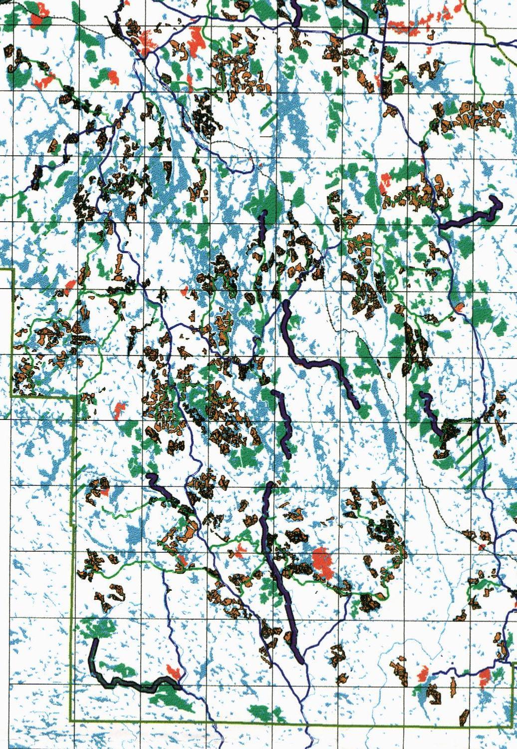
Legend: ![]()
Green: This is the prime area to be logged
Reddish Brown: Contingency Harvest Area - not sure what that means
Ochre: Area to be re-seeded
Black: Highway Corridor
Purple: Secondary Road Corridor (there are some new roads proposed)
Shaded: Area not covered by Plan (e.g. towns, and in green: prov. parks)
(To see the areas that have been logged already, click here for the Previous Logging Plan by E.B. Eddy)
| From the critique of the Spanish Forest Management Plan 2000 to
2020: A. The FMP does not protect canoe routes and portages adequately. Even though some are in the plan, most canoe routes and portages are missing. Thus, canoe routes and portages cannot be protected by Domtar staff as they don’t know about them, the MNR cannot manage protection of these values, and reviewers of the FMP cannot verify whether the FMP protects adequately. Also, the reserve along portages and lake shores is inadequate to protect from blowdown and view deterioration. Last not least, the use of motorized vehicles on and near portage trails destroys the character and even the surface of the portage trails.
These are significant shortcomings because:
To address this shortcoming, the FMP should be revised to:
These updates need to be integrated into the FMP, and its maps updated to establish reserves and modified zones.
Other shortcomings of the FMP 1. ATV’s as a significant threat to wilderness values are inadequately addressed in the plan. Unless a serious effort is made to stop ATV’s, the intended protection of lakes and natural areas will not work. The prescribed controls for vehicle access look inadequate to me as I often encounter portage trails that are chewed up by ATV traffic. Especially, the combination of pick-truck and ATV overcomes the plan’s intend to stop motorized access. Effective measures against misuse of ATV’s would include sufficient funding for enforcement of the rules and significant fines to offenders, including the impounding of vehicles. 2. The lack of native input is deplorable. I understand the reasons for lack of input and that it is a difficult job to reach agreement. But unless some consensus has been reached with the native communities, this part of the plan lacks credibility. 3. The parks that are defined in the Ontario Living Legacy Plan are not adequately protected. The allowances for these parks are not generous enough and hem the park in at the lowest possible denominator. E.g., the Spanish River Park is given the narrowest possible protection along the shore lines of river and lakes. Given that the implementation of these parks will happen after cutting begins, staff from the Parks Ontario should review the FMP and define a temporary reserve that will protect larger areas and the viewscapes before logging destroys these areas.
|
Click here to get back to Erhard's Home Page
Click here to get to Erhard's Favorite Paddling Areas