Kanu ![]() Links
Links
The McCrae Lake Conservation Reserve
The consultation announcement for the boundary definition
Fall 2000
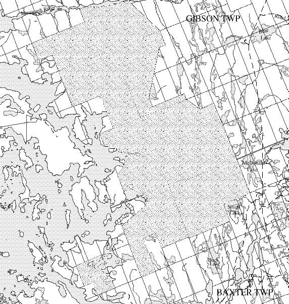
MCCRAE LAKE CONSERVATION RESERVE (C36)
 Click on the image on the right to see the map
FACT SHEET (
October 2000)BACKGROUND
On July 16, 1999, the Ontario Government released the Ontario’s Living Legacy Land Use Strategy to guide the planning and management of Crown lands in central and parts of northern Ontario. A major part of the Ontario’s Living Legacy Land Use Strategy was a government intent to establish 378 new protected areas. This commitment marks the biggest expansion of provincial parks and conservation reserves in Ontario’s history.
The proposed McCrae Lake Conservation Reserve is part of this significant expansion of Ontario’s protected areas system.
SIZE AND LOCATION
The McCrae Lake Conservation Reserve is a 1,889 hectare area of Crown land located in Gibson Wardand northern Baxter Ward of the Area Municipality of Georgian Bay, in the District Municipality ofMuskoka. The site extends from the southern shoreline of the Gibson River southwards approximately 7 kilometres, encompassing the shoreline of McCrae Lake and the Crown lands on Bearshead Lake. It reaches Georgian Bay in several locations. Its southern limits are about 3.8 kilometres due north of Honey Harbour. It abuts the proposed Gibson River Conservation Reserve to the north.
A proposal to extend the proposed conservation reserve to the north-east of the site, in the vicinity of Concessions 2 to 5 in Gibson Ward, is currently under review.
AREA HIGHLIGHTS
This conservation reserve is in ecological Site District 5E-7, and provides representation of the thinly till-covered rolling bedrock outcrop landscape of the area. The landscape is characterized by bedrock knolls with red oak, white oak and white pine, containing a number of species at the northern end of their range. The area is scattered with small wetlands and beaver ponds, with several rare plant and animal species. The southern portions of this area have been municipally designated as a Muskoka Heritage Area. The area around McCrae Lake has been regulated under the provincial Wilderness Areas Act for over 20 years, and is a popular canoeing and camping area.
LAND USE INTENT
Conservation reserves are areas of Crown land set aside by regulation under the Public Lands Act. Conservation reserves complement provincial parks in protecting representative natural areas and special landscapes. Most recreational (e.g. hiking, skiing, tourism related uses, nature appreciation) and non-industrial (e.g. fur harvesting, commercial fishing and bait fishing) activities that have traditionally been enjoyed in the area will continue, provided that these uses do not impact on the natural features needing protection. Hunting and fishing are permitted within all new conservation reserves recommended through Ontario’s Living Legacy.
Commercial timber harvesting, mining, aggregate extraction and commercial hydroelectric development are prohibited in conservation reserves. Careful mineral exploration may occur in specific new conservation reserves proposed through Ontario's Living Legacy, in areas that have provincially significant mineral potential. If a portion of a new conservation reserve is to be developed for a mine, it would be removed from the reserve, and appropriate replacement lands would be placed in regulation.
NEXT STEPS
The Land Use Strategy established the Ministry's intent to add these Crown lands to Ontario's protected areas system, following the extensive public consultation associated with the Ontario’s Living Legacy and Lands for Life land use planning initiatives between 1997 and 1999. Prior to the finalization of the boundary of this conservation reserve recommended for regulation under the Public Lands Act and consistent with the Ministry’s Environmental Assessment Act responsibilities, the Ministry is inviting public comment on the proposed boundary from all potentially affected stakeholders between October 2 – November 2, 2000. The Ministry is committed to ongoing consultation with First Nations who are potentially affected by OLL decisions. In the interim, the area has been withdrawn and protected from resource extraction activities such as timber harvesting, hydroelectric development, aggregate extraction and new mineral exploration.
In the future and subject to the intended regulation of the area as a conservation reserve, the Ministry of Natural Resources will prepare a long term management plan for this area. Depending upon the complexity of issues within this conservation reserve, management planning may take the form of a simple Statement of Conservation Interest or a more detailed Resource Management Plan. Please let us know if you would like to be consulted regarding this planning document.
Planning, management and the uses permitted within this conservation reserve will be consistent with the commitments of the Ontario’s Living Legacy Land Use Strategy.
FOR MORE INFORMATION
For further information on the proposed McCrae Lake Conservation Reserve, please
contact:
Dorothy Shaver, District Planner
Parry Sound District
Ministry of Natural Resources
7 Bay Street
Parry Sound, Ontario
P2A 1S4
Telephone: (705) 773-4231
Facsimile: (705) 746-8828
You may also visit the Ministry’s Internet website at www.ontarioslivinglegacy.com
for information about Ontario’s Living Legacy.