|
| |
Kanu  Links Links
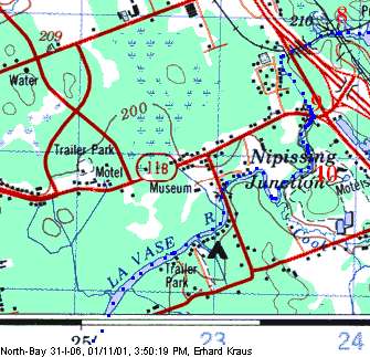
The LaVase Portages:
LaVase River Towards Lake Nippissing
| Continued from Upper Section, at the
lake beside the Fabrene Plant/Pumping Station:
- N 46.26832°, W 79.39284 °
Continue underneath railway bridge and two highway bridges before coming to a sharp
bend to the left.
This was the start of the third historic portage, now hidden beneath a subdivision
and driving range.
Modern travelers should keep to the river and run (high water), wade or portage the
two or three shallow swifts leading to Lakeshore Drive.
- N 46.26312°, W 79.39522 °
There, take out before the bridge on the left side at a small parkette and portage
190M across the road, down a steep embankment and along the left side of the rapids to a
put in.
- N 46.26072°, W 79.39553 °
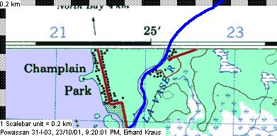
A short distance downstream is a ledge that can be run in high water or lifted over
later in the season. Immediately around the corner is another small set of rapids that can
be run in high water but will require portaging throughout most of the season.
The river now turns lazy, with cottages and homes mostly on the left shore. You
nearly made: it's only another 3.5km to Lake Nipissing and the
take-out in Champlain Park.
N 5121930 m, 17 621822 m
N 46.24199°, W 79.41986 °
|
|
Note about the map:
 | Copyright: Extract of the data sets
North Bay_31I06 at 1:50,000
©Her Majesty the Queen in Right of Canada
Reproduced with the permission of Natural Resources Canada
|
| The maps were produced with QV Touratech using the topomaps from QuoVadis. |
Back to the LaVase Portages Page
|