Kanu Links
![]()
Canoe the Obabika Loop in
Temagami
All photos will expand when you click on them
In August 1997, five canoes from the Federation of Ontario Naturalists (FON) paddled
the Obabika Loop and proved again that this route is one of the nicest the Temagami
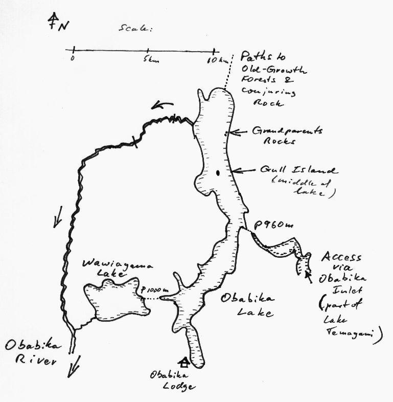
region. For a map of the route, click here.
Day 1:
We travel to the Obabika Lodge at the southern
end of Obabika Lake where we launch the canoes. Note that
this access is now closed, and the Ontario Ministry of Natural Resources advocates
to paddle in via Temagami Lake and the portage of Obabika Inlet. 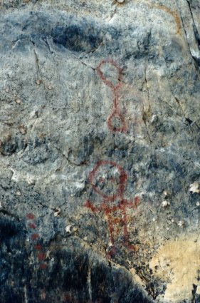 The south end of the lake is somewhat busy with the boats from
the lodge and a handful of cottages, but it gets quiet as we move up the lake. It's neat
to glide over the sun-lit sandy bottom near the shore and look at the magical world under
water. Further up, along the left shore, where the cliffs come down to the water's edge (in
Anishnabe language, they are called Kaw-gaw-gee Waw-bee-kong), pictographs from
travelers long ago give us time to marvel and reflect. The
further north you camp on this lake, the more likely are you to encounter other campers
and you might find the camp sites occupied. Thus, we paddle about two fifth up
the length of the Lake and camp on the left shore.
The south end of the lake is somewhat busy with the boats from
the lodge and a handful of cottages, but it gets quiet as we move up the lake. It's neat
to glide over the sun-lit sandy bottom near the shore and look at the magical world under
water. Further up, along the left shore, where the cliffs come down to the water's edge (in
Anishnabe language, they are called Kaw-gaw-gee Waw-bee-kong), pictographs from
travelers long ago give us time to marvel and reflect. The
further north you camp on this lake, the more likely are you to encounter other campers
and you might find the camp sites occupied. Thus, we paddle about two fifth up
the length of the Lake and camp on the left shore.
Day 2:
We continue paddling up the Lake and stop about half way up the northern
part of the lake, at the large rock island. During spring, it's a seagull rookery, but in
August it's just one large rocky whale's hump, way out in the lake and bare of vegetation.
Its gently sloped shore makes it easy to pull up the canoes, and we explore. 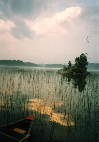 No birds are there now, but
the evidence of its large spring population is soon obvious: feathers have been blown into
every crevice in this rock. But what touches us deeply are the many bones that are strewn
about. In a place where so much new life springs forth, death seems to take its casual
toll as well. We paddle on, all a bit quieter than before... Near the top end of the lake,
we camp on the left shore, on the beach. Obabika Lake(Photo: Bonny
Brownstein)It's a comfortable site, with the tents pitched directly
on the sand. A small rocky island, just 50 m off shore, is a nice target for a swim, and
we admire the brecchia that forms its bedrock.
No birds are there now, but
the evidence of its large spring population is soon obvious: feathers have been blown into
every crevice in this rock. But what touches us deeply are the many bones that are strewn
about. In a place where so much new life springs forth, death seems to take its casual
toll as well. We paddle on, all a bit quieter than before... Near the top end of the lake,
we camp on the left shore, on the beach. Obabika Lake(Photo: Bonny
Brownstein)It's a comfortable site, with the tents pitched directly
on the sand. A small rocky island, just 50 m off shore, is a nice target for a swim, and
we admire the brecchia that forms its bedrock.
Day 3:
It's lay-over day on Obabika. Heavy rain and lightning have forced us to
stay put. Everyone is huddled under the large kitchen tarp; we are cramped but glad to be
sheltered from the elements. In mid-afternoon, the weather improves and we decide to make
use of the day. We launch the canoes and paddle to the north-east corner of the lake where
there are large stands of old growth white pine. We step on shore and follow a trail
that leads up the forest, take a fork to the right, cross a creek and then
reach the top of the cliffs where we lunch. We are a group of nature buffs and thankful
for the chance to look at the plants in detail. 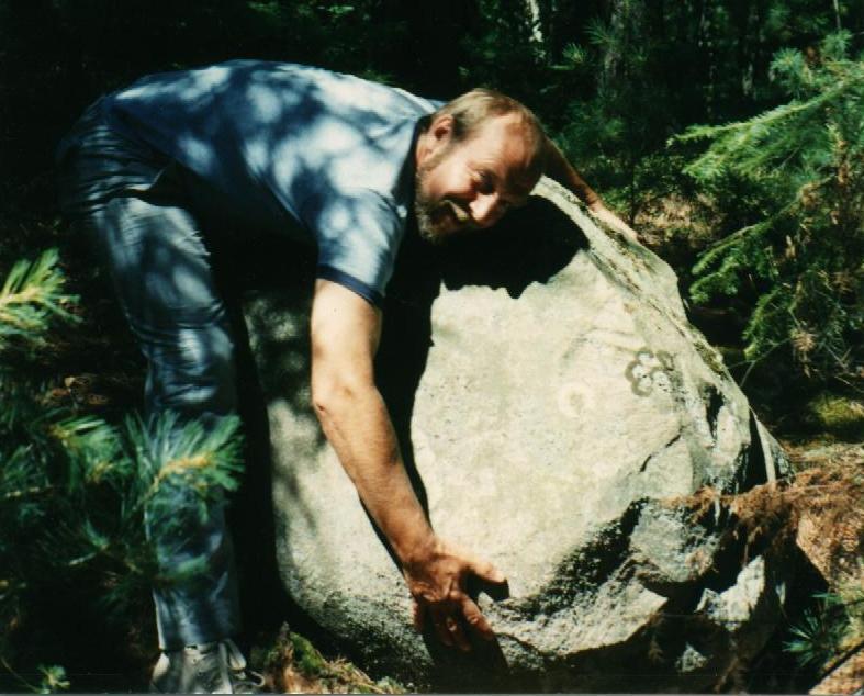 With
opened guide books, we stand huddled over some little sprig of green with a blossom and
sort out what it is and what it isn't. I love this: in the three or four hours of
walk, we barely cover 4 km, and it's time well spent. Eventually, we get back to the boats
and realize that we would rather paddle for another hour than return to the camp for
dinner. So, we move south along the east shore of Obabika Lake, to the Grand Parent Rocks
(Ko-ko-mis and Sho-mis Waw-bee-Kong) and the pictographs there. We have
seen these strangely sculpted rocks from a distance, and are keen to check them out. It's
a privilege to get up close to these monuments of Native history and connect to the
hundreds or even thousands of years of human presence at the lake.
With
opened guide books, we stand huddled over some little sprig of green with a blossom and
sort out what it is and what it isn't. I love this: in the three or four hours of
walk, we barely cover 4 km, and it's time well spent. Eventually, we get back to the boats
and realize that we would rather paddle for another hour than return to the camp for
dinner. So, we move south along the east shore of Obabika Lake, to the Grand Parent Rocks
(Ko-ko-mis and Sho-mis Waw-bee-Kong) and the pictographs there. We have
seen these strangely sculpted rocks from a distance, and are keen to check them out. It's
a privilege to get up close to these monuments of Native history and connect to the
hundreds or even thousands of years of human presence at the lake.
Day 4:
It's time to move on, as we intend to paddle
down the outflow of the lake for about a day and a half, and then loop back into
Obabika Lake via a side creek, a lake and a long portage.
So, we break camp and retrace our way southwards for about 2 km and then enter the Obabika
River. A cabin stands where the river leaves the lake, smoke curling out the chimney, a
vegetable plot covers a fertile strip of shore and two dogs are barking at us. This is a
strange sight in what I thought to be wilderness. But the owner of this home may well be a
descendent of the people that have left their paintings on the rocks nearby, so why should
he not continue his way of life...
The river is small, just big enough to float our five canoes in loose formation. Its clear
water flows over a gravelly bottom, and the incessant bends make for slow progress. The
August sun burns down and dulls our senses, and the only life visible is the dragon flies
that cruise about. We identify the bird songs that come from hidden perches in the bush
and, occasionally, see moose tracks where the river bottom is soft. Two weeks earlier, the
shores had revealed many tracks of not only moose but also bear and wolf. The recent rain
has erased their tell-tale tracks and all open shore lines are as smooth as blackboards,
awaiting to be rewritten.
| An encounter with the people that live at the start of the Obabika, by ChrisCanoe, mailed to me on Jan 1, 2000: "...We had been enjoying the SW winds by joining 2 canoes together and sailing up Obabika Lake. It had been raining since we woke that day, but since there was such a great wind we decided to take advantage of it and keep on moving (we were doing route 6). When we got to the narrows (1/2 way up Lake) the wind was getting a bit much but we pressed on. Well let me tell you, we were really moving with the wind when all of a sudden it started getting a little hairy so we decided to pull in to the bay by the Obabika river and seek shelter for a while. After pulling up on shore we also noticed the camp (fire smoke) so we decided to go and introduce ourselves. Well we were totally soaked and as we approached the camp we noticed they were native and they invited us over. To keep it short, they invited us to spend the night, hang up all our wet stuff inside the cabin, invited us to join them for dinner (fresh moose stew and moose steaks) and lots of coffee. The rain stopped around 7 pm so we all went out and enjoyed a great fire while we talked about Temagami. They are members of the Gibson tribe.... Having been involved in the Temagami blockade a few years ago I found it fascinating to hear what they had to say. The Chief was there and he was the friendliest person you could imagine, showing great hospitality and generosity. The big thrill for me that night was when he asked me if I would like to stay in one of the teepees instead of putting up my wet tent. It was not that big, but when I unlashed the opening and crawled in, I was in heaven. There was a good bedding of straw that was covered with animal hides. I had the best nights sleep nice and dry and warm, staring up through the hole at the stars. The next morning when I crawled out the chief was already up getting the fire going again, and we enjoyed more talks over a few coffees before they wished us well and we continued up to the Wakimika River." |
We carry around the small unnamed rapids 2 km from the start of the river. On an earlier trip, I had seen Cedar Waxwings perched high above that shore flutter out whenever an imprudent insect tried to cross the open space on the river, but today they are missing. We pass the portage towards Lahay Lake and judge the trail to be a bad one: it is swarming with mosquitoes and quite overgrown. Then we continue to Kokosh Pow-waw-ting or Pig Rapids, a short carry of about 90 m, and pitch tents on the large camp site there. It's good to know that across the river there is the open space of a former logging camp which could be used if the main camp site were occupied already.
Day 5:
We get up early as we expect it to be a long day. Launching the canoes brings out a new
but not uncommon hazard: a tree stump houses a nest of bees, and
we have to pass close by to get to the put-in. A few in
the party are stung, and we are all glad as we get away from there.
For about six hours, we follow the many bends of the river, and the canoes have to be
pulled over the dead trees that often bar the way. Then, some hillocks appear above the
left shore, a sign to look for the little creek that enters from the east. We enter
Wawiagama Creek and paddle against the current, skirting bushes and sandbars. After an
hour of such toil we enter the bulrushes of Wawiagama Lake and search for a camp site. 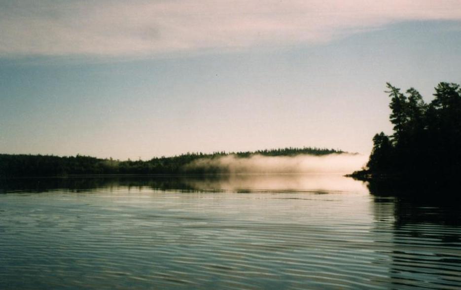 The north shore of this lake has nothing to offer this medium sized
group, but on the south shore we find a site large enough for just about any group.
Some bare rocks nearby give us a chance to freshen up with a swim; what a pleasure!
The north shore of this lake has nothing to offer this medium sized
group, but on the south shore we find a site large enough for just about any group.
Some bare rocks nearby give us a chance to freshen up with a swim; what a pleasure!
Day 6:
The day starts with a 1000 m portage from the eastern end of Wawiagama Lake. It's not tough, really, because it's level and clear, and we soon get our gear to the other side. It's on the western end of a deep bay of Obabika Lake and, at earlier days, seems to have seen lots of traffic: there is even a wooden dock built for some obscure purpose. We should be paddling south on the lake to get close to tomorrow's pick-up, but the good campsites are the other way and we head north, along the west shore. Finding the camp site of the first day occupied, we cross Obabika Lake and settle down on a small site, up a steep hill. In spite of the small site, we manage to get comfortable and soon goof around to pass the remainder of the day. One couple even heads back across the lake to scale the huge rock face, and we watch them through binoculars as they work their way up to reach the wooded top. Yes, we are on alert for bees, again, as there are a few buzzing around, but no one is stung this time.
Day 7:
The morning sees us paddle back to Obabika Lodge for the pickup. We are relaxed, easy with each other and a bit wistful that it's just about over. Maybe we'll be back the next year....
Erhard Kraus,
June 1998
Evaluation of Route:
The route is suitable for beginners; but the long second day on the river with eight hours of paddling, the many fallen trees and the subsequent ascent of the shallow creek could be a frustrating experience for a weak paddler. Waves can build up on the lake, especially if strong north/south winds prevail. This route is well documented in Hap Wilson's book "Temagami Canoe Routes": the river is described in Route 11 and Obabika Lake itself in Route 6.
Caution: the access at the Obabika Lodge has been closed to the public. I recommend the access from Lake Temagami via Obabika Inlet and the 940m portage.
Acknowledgement: Photos by Bonnie Brownstein and Barb Hankins (Erhard with rock). The pictograph was found in the website of the Obabika Lodge.
Click here to get back to Erhard's Home Page
Disclaimer
The advice provided in Obabika Loop has been compiled based upon 30 years experience canoeing in Ontario. Every effort has been made to ensure that the advice in this web site is correct. Even so, I do not accept any responsibility for errors or misrepresentations contained herein.
WARNING! This advice is intended for use by those with some prior experience in camping, canoe-tripping and backpacking. I do not assume responsibility for the safety of individuals, nor do I accept liability for any loss or damages that might arise in the course of following the advice presented in this web site.