Kanu Links
![]()
Canoeing the Mattagami River
in Northern Ontario
In July 1991, I paddled the Mattagami River with my
(then) 20-year-old son Ed. Paddling this river is a good lesson on what the North is
really like. The river takes you through polished rocks of the Canadian Shield Country,
shores covered in spruce and aspen, past huge gravel bars full of strange fossils and into
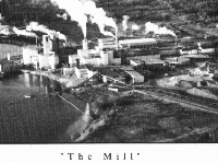
the monotony of Hudson's Bay clay lowland. But there also is the stench of a pulp mill,
the obscene clearcuts on the land beyond a frail seam of forest, and sections of the river
that are so efficiently dammed that one needs to make arrangements for a shuttle to skip
the uncanoeable sections. Camp sites are not always where the ministry brochure has
indicated; making your own camp site is often impossible because of the dense brush; and
the water levels in some sections are susceptible to sudden changes.
The trip started in Smooth Rock Falls and ended in Moose River Crossing, about 2 days paddle from Moosonee. The retun was done by train and hitch-hiking. For train information, contact Ontario Northland. The name of the river comes from the Anishnabe (Ojibwe) word "madágami" which stands for "troubled or agitated water" (Frederic Baraga's Dictionary of the Ojibway Language of 1853).
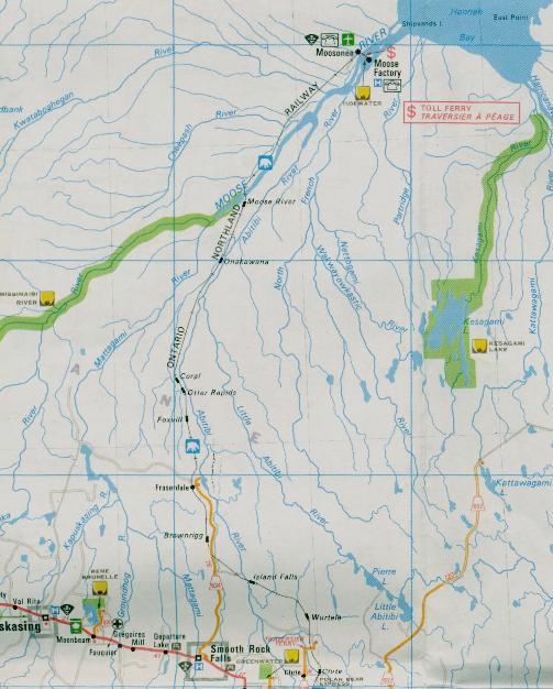
The map will expand when you click on it
Day 1, July 16:
This is a travel day. We leave Toronto around 8 am and, after about six hours driving, stop in the town of Cobalt for a break. Cobalt is a typical northern town, lacking pretense as its people are open and friendly. It also is a town that has been fighting for survival ever since the silver mines closed down. In the local museum, there are the trophies of its days of glory: lumps of ore and of pure silver, and sepia photographs of men crowding around mining sites. It was a bustling place then and the main street had a vein of silver running down the middle. We sit still for twenty minutes to watch a video with the outline of that history. The boom started in 1903 and came to an end in 1925. After it was all over, 200,000,000 ounces of silver had been brought up from the mine shafts and sent by train down south for processing. At $.60 per ounce, this this was a fortune of over 100 million dollars, at a time when a good house could be had in Toronto for maybe a thousand dollars. Now, as the mines lie still and the town is barely alive, the narrator asks "Where did the money go?".
We drive on, passing through the farming area near New Liskeard. This is a surprise to us folks from the south who had only expected spruce, rocks and lakes but not corn fields and barns. On to Cochrane, to sort out logistics for later because at the end of our trip, the train will drop us off here. I note the bus terminal and a place where I could hitch-hike easily if I wanted. We make the mistake to eat in a place whose decor would be more at home in Texas and, of course, the food is the worst that fast food can be. I guess food is not as easily copied as decor...
We drive on to Smooth Rock Falls and immediately look for the put-in. The ministry brochure directs us a few kilometers north of the town, along some weed-lined side roads that end beside the river. The place is an ugly wasteland and is not suitable for a start because I expect to return hitchhiking. That would mean a long walk from the highway to the car. We drive away from the water and pitch tent at cross-country ski club's meeting place, where no one challenges us and where there even is a flush toilet. We will figure out tomorrow where to launch the canoe...
Day 2
We break camp and drive back to the road and the town. Right beside the river is the Pulp and Paper Mill, with an upstream dam to generate power, a smoke stack that belches ugly clouds and an evil-looking lagoon that is meant to settle pollutants before the water is allowed to re-enter the river. We eat in town, in a little place full of locals. The language spoken here is Quebecois French, belying the southerner's belief that Ontario is an English-speaking province: as usual, the truth is in the details. The owner of the joint switches effortless into English and offers help: why not start at the pulp mill? We follow his advice and pull into the factory gate. Permission is given readily and, after dropping the canoe and gear, we park in one of the rows of employees' cars.
Paddling starts out as a "run from the impure". It's easy to get away from the immediate stench of the smokestack as the wind mercifully blows not exactly downriver. But the river itself stinks from the sulphurous effluent and this aroma will be noticeable even on the following day. Islands of scum float lazily in the current, eventually breaking up and to form again at the next rapid. The ugly brush that accompanies human spoilage of a northern site soon gives way to black spruce, birch and poplar and so, after a while, the mind accepts that we have started a wilderness trip. Rocks are black and often well-hidden by the dark water. There is wildlife: twice we surprise bears that forage on the the vegetation of the shore. We sneak up to within 50 ft of one of them, before he notices us. He is a big guy, who first strains eyes and brain as he realizes that we don't belong here, but then something seems to click and he huffs into the bushes to escape. We have seen his face and later that evening, I document in my diary the near-human expression of his face: "curiosity and boldness, with a touch of cunning and distrust".
A motor boat comes upstream and stops beside us. The two men have been sampling the water for dissolved oxygen further down the river and they chat with us. Such talk is a way to be sociable and but also elicits information about what we are doing. They are curious that we want to paddle that far and give some advice on the rapids coming up. Also they acknowledge, when asked, that the mills pollution ends up in James Bay. "Drink the water from the side streams, not from the river!", they advise. Their questions towards us probe whether our experience matches the challenges ahead and I guess we pass.
Fish Rapids are low and we will not run them. At high water, they can be powered through by motorboat on the left, we have been told. At the next rapids, Scar Rapids, we paddle through on the right centre, and make camp on an island about 3 km further down, which is the first suitable site we have seen since the morning. The site is small, there is poison ivy and it is not even flat. Some grass nearby has been pushed to the ground, but in the absence of other signs of possible previous campers, we conclude that a bear has rested here.
Day 3
This is definitely bear country: we surprise two more of these mammals browsing on the shoreline vegetation. This is a good day, with easy rapids one after another. The river is full of rocks, and the deep channel keeps shifting from one side of the river bed to the other. If one has misjudged, one paddles in shallower and shallower water until it's obvious that all the water has pulled to the other side of the river and one needs to drag the canoe through shallow ripples to regain the deep channel.
At Katikumabi Falls, we judge the rapids as runnable but decide to line anyways to play it safe. About 1 km further, on an island, is a good campsite. We see our first bald eagles, and are surprised by the snowy white of their head and tail. Huge birds, they are... A bit further, we stop at a good-looking cabin beside the river, just to look. A trail grooved by ATV tracks leads into the thick forest behind it, and we follow it. After 150 m, a surprise awaits: the forest ends and the land is wide open to the view.: a clearcut, everything is a clearcut. Hill after hill as far as one can see. Dry slopes and sparse poplar trees (meant to reseed the area) have replaced the forest, and roads everywhere, just like in a freshly bulldozed subdivision. Bone-dry branches and trunks of rejected tree make the area look like a warzone. We are stunned; we poke around the dust and dirt to make sense of this plunder, and then retreat in silence to our rivershore.
Cypress Falls starts with a rapid that we run at the top and then portage on the right, for only 50 m. We decide to stay at the good campsite there for night. After a failed experiment to make tea out of the blossoms of goldenrod (the tea makes your throat feel scratchy) we console ourselves with the bottle of white wine that we brought along. As darkness settles, clouds are also moving in.
Day 4
In the morning, we awake to pouring rain. But soon the weather eases and it's just cloudy and windy. We are surprised by how fast the weather changes in this area. We have entered the upper stretches of a lake formed by the Little Long Dam; there is no current and of course there are no more rapids for the remainder of the day. The Groundhog River enters from the left; it is just as big as the Mattagami and, a bit later, the Kapuskasing River enters with two arms.
The wind shifts from SW to W and the sky clears, except for a steady drift of "thunder floats", as we call them: dark puffy clouds with bright edges and blackish curtains of rain hanging out at the bottom. Two motor boats come towards us; they slow down and we exchange greetings with a wave of hands. As we paddle this lake, we pass three camp sites on islands, all within the 10 km stretch past the northern branch of the Kapuskasing River. But we try to get closer to tomorrow's rendezvous-point with the driver of the upcoming shuttle around the dams and paddle further. We are disappointed as there are no more campsites: maybe the powerful erosion has erased the sites that were marked on the map. Just before the river widens to about 5 km, a large sign on the right indicates the rendezvous-point. There is a parking lot and plenty of trash. We camp close to the sign, on level and hard-packed clay. We have again reached "civilization". Apprehensive about a possible visit from a curious bear, we take extra care when we tie the food out of reach. The night is clear, and the northern lights play wildly across the sky.
Day 5
The pick-up was arranged for 9 a.m and we are all packed to go. The shuttle is necessary because, according to the ministry brochure, "Beginning at the Little Long Dam there is a series of four dams covering a distance of 21 km. It is not recommended to travel this section on the river by canoe. Automatic floodgates control the water levels between the dams and water can be discharged at any time. To bypass the dams arrangements can be made to have your equipment transported by private individuals from Smoky Falls. Contact the Chief Operator, Smoky Falls, P.O. Box 190, Kapuskasing, ON P5N 2Y3 or telephone (705) 337-9706. There is a charge for this service."
| February 2004: The shuttle service exists no
more. Some kind soul had sent me an email with that information, and, unfortunately, I
lost the email and cannot give the details. Nor could I thank the writer - so let me try
and do it here now: Thanks A Bunch! From the Ontario Power Generation website, I read that the dam is now remotely operated out of Porcupine, near Timmins. That explains why there is no longer company staff stationed in the area. I am not sure how one could get a shuttle around the dam. |
So, we are waiting for Stephen Johnson, and he does not show. Noon passes, and by early afternoon, I stop a car in order to get a message to him, in case he forgot. The weather turns gray and nasty, and we pitch the tent again. Finally, at 7:45 pm, a pickup truck pulls up, with Stephen at the wheel. There was construction, and the dam road has been closed until now. We fold the tent and load up, us in the front and canoe and gear in the back.
Stephen lives in Smoky Falls, a company "town", and he is a powerhouse operator. He is about 32 years old, with a wife and 2-year-old baby. He has never traveled the river, but he has been to Moosonee by train. Life in the north is good to him, and he has tried the south but hated it. Smoky Falls consists of 12 houses, including a large rooming house for the bachelors of this place. There is a "shopping Bus" twice a week and aside from work, there is hunting and fishing. Steve might move away some time later in life though, he says.
He drops us off at the last dam, Kipling Dam, at a large mosquito-infested clearing and we stay there for the night.
Day 6
There's no water in the river! The tap's turned off, and not a drop spills from the silent dam above us. There are puddles and pools in the rocky riverbed, and we drag and lift the canoe down-stream, hopefully towards more water. After a while it gets easier and we can discern a trickle, and in many places it's deep enough to paddle. Eventually there is a current again, permitting normal travel. After about 20 km, a huge gravel bar appears from the right, the result of man's meddling with nature. A spillway was built to allow the routing of water around the dam systems enters from the right. It is dry now, but its must hold huge volumes of water have flushed the whole contents of the Adams Creek bed into the Mattagami river to form that gravel bar. A bit further downstream, the Mattagami cuts spectacularly through the high gravel bank and positions itself to the right of the gravel. Later it moves to the left of the gravel bar again, and there trickles over a long rim of pebbles, to form a pretty a silvery lace several hundred meters long. A stop at the shore reveals that many of the rocks are fossils, that include strange cow-horn shaped stones that I have never seen before. This place is enchanting!
We camp half way between Cockshutt Creek and Grand Rapids, on a gravel bar, well away from the water. As we eat dinner, we notice the water has been rising and prepare for a quick escape, if this should become necessary. The canoe is pulled up onto the clay shore and we place sticks on a line between the tent and the water to keep track how fast the water is rising. The precautions were prudent but there's no need for panic as the rise of the water slows around 10 pm and eventually stops about 20 ft away from the tent. During the night, we check occasionally to assure us that the river has stopped its rise.
Day 7
The day starts well with good weather and a steady flow of water. There are rocks and rapids that require maneuvering and several times we get out on shore to scout before running the swifts. At Grand Rapids, the paddling becomes tricky. For about 2 km, the river flows over slabs of limestone and we try to keep the canoe in the channels between the slabs where the water is deep enough. Eventually the channel comes to an end, usually at a cleft in the rocks that runs perpendicular to the current, and we have to find a new channel. With an ABS canoe, this would be no big deal, but our canoe is made of fiberglass and we are afraid we might crack the hull. Our nerves are on edge and we both are glad when these rapids end.
Later, we come upon a big unnamed rapid, formed by a ledge, and we decide to portage the 30 m rather than run the huge standing waves. The next rapid, Long Rapid, is no worse than the many class I rapids that we have paddled so far we paddle through. Eagles and hawks appear again at this stretch of the river, but we are tired, and maybe stressed out from Grand Rapids, and don't get excited any more. Ed looks like he'd rather be somewhere else and I realize we are reaching a critical point of the trip. As I am apprehensive about the uncertainty of finding safe camping at Moosonee (unfounded, I find out later), we talk and agree to shorten the trip by pulling out at Moose River crossing, about 2 days short of the planned finish. This puts Ed at ease and makes me happy too. We camp a short distance below Long Rapid on a gravel bar and have a good dinner with the remaining wine. During the evening, the wind swings to blow from the south and we feel the moisture in the air, just as if we had entered a steamy bathroom. Soon, the skies open up and sheets of rain hammer against the tent fly. I hope the tent will hold up....
Day 8
The rain stops and a steel-blue sky replaces last night's clouds. The tent has stayed dry, the river carries a good volume and we are in good spirit. The river is wide now, with campsites on the many sand bars. But the shore line is boring. It flanks a boldery riverbed, with slanted clay shores and scruffy flats of spruce above. The Missinaibi joins from the left and the river now called the Moose. There, we look but cannot find a sulfur spring that is supposedly there. As we continue, we make good speed as a strong tailwind pushes us briskly forward. Not long later, the many spans of the railway bridge appear, marking the end of our trip at Moose River Crossing. We pull out at the upstream end of the island that is spanned by the bridge and walk over to the train stop. The next train leaves tomorrow morning and we will have to spend the night here. The top of the island where we landed has an abandoned cottage and we pitch the tent beside the raspberry bushes. The night passes uneventfully.
Day 9, July 24
The train is supposed to leave around 10:15 a.m., and thus we have moved our gear over to the "platform" early. Three more canoeing parties arrive and lug their gear up from the river. They are separate groups, and all have paddled the Missinaibi, which is the most popular river up there. They all had a good time, and the scruffy folks talk of rapids and falls and sturgeons working through shallow rapids so their fins stick out of the water. But none report bald eagles nor bears.
The train arrives at 10:20, and it's a strange train: a diesel engine pulling about 30 freight cars, 4 passenger cars including the dining car and, at the end, three baggage cars. The canoes are loaded into one of the baggage cars. We take a seat and pay $73.85, the fare for two guys and a canoe. Most passengers are natives and there are many children. Looking out of the window, I am surprised at the uniformity of the land: endlessly flat bogs with spruce sprinkled across it. I'd hate having to walk across it. Later, we cross a river and there are forests. I, a "southerner", feel at ease again.
In Cochrane, the end of ride, we get off and unload our gear. Ed stays behind, while I hitch a ride to Smooth Rock Falls to retrieve the car. Getting a lift is easy, the car is where we left it and soon we are both on the road again, heading back to the city.
Home Back to Erhard's Home Page
For the curious:
| I found a webpage with a description of how the native Anishnabi of the area have paddled in the early 30's. In the author's words, "This is a chronological account of a canoe trip made from Chapleau to Moose Factory via the Missinaibi River in July 1932. It was put in writing as the trip progressed.". What is casually mentioned at the end of the trip is that the party returned by going upstream back the Moose and taking the Mattagami and then the Kapuskasing River to get back to the railway and eventually home. in their words: "...it was made in 12 days traveling time from the junction of the Mattagami and Missinaibi Rivers. For the first two or three days we propelled the canoes with poles as paddles were useless against the fast water and rapids." Unfortunately, the website no longer exists.... | |
| And what it's like to go to Moosonee by train! (If the address changes, use an internet search facility like Google and locate where Hans Boldt keep his Moosonee webpages.) |
Disclaimer
The advice provided in Canoeing the Mattagami River, by Erhard has been compiled based upon 30 years experience canoeing in Ontario. Every effort has been made to ensure that the advice in this web site is correct. Even so, I do not accept any responsibility for errors or misrepresentations contained herein.
WARNING! This advice is intended for use by those with some prior experience in camping, canoe-tripping and backpacking. I do not assume responsibility for the safety of individuals, nor do I accept liability for any loss or damages that might arise in the course of following the advice presented in this web site.