Kanu Links
![]()
Maps and the Computer
News item for the paddler(June 2000):
There are now available detailed topo maps for Ontario, on CD-ROM!
Up to now, Ontario has been poorly served with just a few areas covered, but that has changed as of June 2000. QuoVadis has published the a CD that has all the detailed topos for the southern half of Ontario, as far north as about Sault Ste Marie, and another CD covering the remainder of Northern Ontario is about to be released. I have been itching to try out these maps. Here's the story: - it's neat one! Two days ago, I came home from a trip in the lands between the Spanish and the Mississagi, locating old portages and scouting camp sites. In a pile of mail, I found the newly arrived CD-ROM. Within an hour I had the thing installed and was well into tinkering with maps and the display tool. To check out how useful the maps are, I would do three basic things: copy a section of a map into a piece of email, locate a specific place on a map, and then use the CD-ROM to plan for a trip and create the hardcopy map sheets that would be needed during the travel.
Note for this webpage and the enlarged displays: the map images
are subject to Copyright:
Extract of the data set... at 1:50,000
©Her Majesty the Queen in Right of Canada
Reproduced with the permission of Natural Resources Canada
For the immediate challenge, copying a small section of the map
so I can include it in a text document. 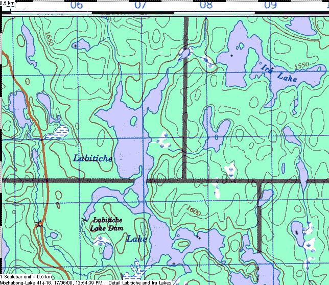 I display the relevant part of the Mozhabong map and zoom in
on the area of interest. There is a "Create Bitmap File" function, as part of
the print feature. I follow the dialogue and create the cut-out in BMP format. Before I
include it in the email, I convert the format to JPEG with a simple right-click of the
mouse- maybe an unnecessary step but JPEGs take less space and thus are smarter to use in
email correspondence. The whole process is fairly straight-forward: Once you have decided
which folders to store things in and how to name the created images, it only takes
seconds. Computers have gotten really useful!
I display the relevant part of the Mozhabong map and zoom in
on the area of interest. There is a "Create Bitmap File" function, as part of
the print feature. I follow the dialogue and create the cut-out in BMP format. Before I
include it in the email, I convert the format to JPEG with a simple right-click of the
mouse- maybe an unnecessary step but JPEGs take less space and thus are smarter to use in
email correspondence. The whole process is fairly straight-forward: Once you have decided
which folders to store things in and how to name the created images, it only takes
seconds. Computers have gotten really useful!
On to the next challenge: find a place on the map, called Poverty Bay Chutes, on the Magnetawan River. I fired up the map viewer that comes with the CDs, and brought up the Ontario overview map to figure out which Topo I'd have to look at. I search for the area of the river that I am familiar with, the place where the Magnetawan crosses highway 69. A right-click with the mouse on that spot, and I get a choice of maps, including the "Key Harbour 41H15" map, and I select it. It takes about 12 seconds to appear, in scale 1:50,000: not bad! In a few more seconds, I zoom in on the specific area: Wow! Here is the image, just as the hardcopy Topo map would look like, except it's under glass and it's very pleasant to look at! I scan, and since Poverty Bay isn't on this section, I start to work my way upstream, just dragging the map with the mouse to the left so that more and more river appears on the right. No Poverty Bay yet, and soon I am at the edge of the map. If I was working with hardcopy, I'd be back to my shelf of maps, scrounging for the adjacent map. As happens more often than not, I wouldn't have that specific adjacent map, either never owned it or it's with a pile of "stuff" somewhere else. Here, on the computer, a rightclick and then a request for the adjacent map: about another 10 seconds, and it's in front of me, right at the junction where I left the other map! I slide further up the river, change maps twice more and finally locate the bay in question. This is neat! As I zoom in and out to play with the different looks, I realize I prefer working here on the glass rather than with the traditional map on paper.
| When discussing this with the QV developers, they pointed me at something that I had missed: the Canadian Names Data Base which is included with the CD. I tried it, and it's a gem: you specify the name of a place and it returns possible place choices from all across Canada, sorted by province/territory. You point at your choice in list, and it will open the map with the most detail; either the topo, or if outside your set of topos, on a large-scale map of Canada. It took me 2 seconds to find Poverty Bay Chutes and another 10 for the display of the map. |
Now for the real challenge: to produce a set of map sheets to take on a trip. Rather than taking the whole darn map, I want to carry just the portion that I will actually need. For this purpose, I decide to "plan" a trip up the Magnetawan, from Hwy 69 to Island Lake, down to Big Deep Bay and return to Six Mile Lake via Lone Tree Lake. I experiment for a while with alternatives and finally resolve to stick with the print function of the utility. The idea is to display sections of the trip and print these sections. For best results, I set the magnification (consistently to 64% on all displays) before printing and used the "Print current map detail" option: it gave me the best utilization of the paper. To cover my trip, I produce 6 pages of generously overlapping letter-sized map sheets. The can be stored in the usual map pouch or water-proofed (that's not so easy: the ink runs when the water seal is applied - I am still experimenting with it, thinly brushed layers seem to work) and kept out, together with a waterproof pen for marking during the trip. Six pages - much easier to handle than the two large Topo sheets, and lighter as well.
| Hint: When experimenting, use the preview function to check that the desired area will be all printed. Also, let your printer switch from "portrait" to "landscape" format. The scale of the printed pages is 1:44,719, i.e. about the same as what you used to work with. As the blue squares of 1 km size are shown, the scale is just fine to work with. Or, during the print dialogue, override the "fit to page" option with the specific scale desired. |
At this point, I am sold on the digital form of the topos. Just to have all the maps at hand clinches the choice, something I could never dream of before. Add to it the display features, the zoom capability, and other features, like showing the distance of a selected point to the mouse cursor, and the choice is even further justified. Finally, by being able to extract pieces of the map electronically and include them in web pages, email and with the word processor, I can do things that would have been at best awkward before. And at the time of this writing, I have not really explored the many functions that the display tool offers.
The future is even more exciting: my GPS, its up/download 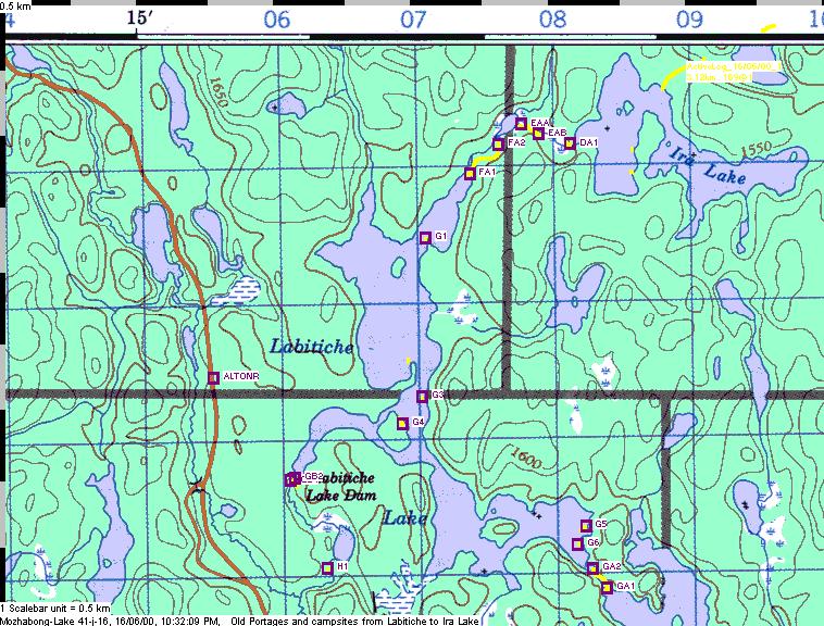 capability
and the electronic forms of the topos all work together. More of that later, but here is a
sampler: the image to the right documents forgotten portages and camp sites that my last
trip rediscovered. All points and tracks are uploaded from the GPS directly into the map.
"Look, Ma, no hands!" Integrated navigation tools are here, finally...
capability
and the electronic forms of the topos all work together. More of that later, but here is a
sampler: the image to the right documents forgotten portages and camp sites that my last
trip rediscovered. All points and tracks are uploaded from the GPS directly into the map.
"Look, Ma, no hands!" Integrated navigation tools are here, finally...
Note for this webpage and the enlarged displays: the map images
are subject to Copyright:
Extract of the data set... at 1:50,000
©Her Majesty the Queen in Right of Canada
Reproduced with the permission of Natural Resources Canada
A bit of background and more info: I had asked for a copy of the topos for evaluation as to their usefulness to a paddler like me. The CDs were provided free of charge, with the understanding that I am free to say what I think. I am thankful to Joachim Bungert for the ready help he extended and wish him and his small team of fellow entrepreneurs the best of luck and success. Like all CD-ROM stuff for the computer, you have to install it. It is no big deal; it takes less than 20 minutes to install the tool that displays the maps and it needs about 60M of hard disk, which includes a Canadian City Data base. The maps originate from Geomatics Canada, the official publisher of Canadian topos. These maps are scanned and compressed onto CDs by QuoVadis in Germany, which also produces the tool that displays the maps. There is a separate license for the fully enabled display tool, but other map display tools OziExplorer can also be used (if you have it already). Order from US or Canada through QuoVadis through Anovo Inc. in Montreal: their website is http://www.qvn-canada.com or go look at one of their partner stores in your corner of the country (for a list, click here). If you place images generated from the topos into WebPages or other published material, you need to respect the Copyright laws. For details on what you may do and how to enter into a contract with the owner of the information, click here. The exploration of the tool was done on my Pentium 133, with 80M memory. I run MS Windows98, with Lotus WordPro as word processor, Pagis as the image editor (it came with my IBM scanner) and Netscape4.72 as the email program. I understand that a more current machinery speeds things up, e.g. opening of a map 2 seconds instead of 10. You may do a lot better than I did.... |