Ontario's Paddling Areas:
The MNR has provided us with a book and map of all its protected areas. Call 1-800-667-1940 and ask for the Ontario Living Legacy package of July 1999.
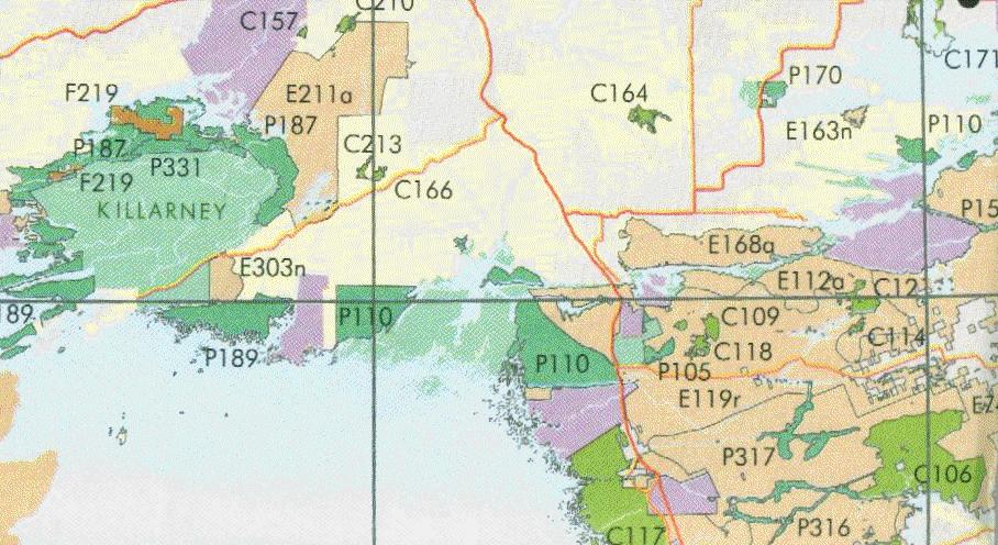
To illustrate, here's a section of the map (the NE corner of Georgian Bay):
| Some existing parks are in pale green (Killarney on the left, French River to the East) | |
| The new parks are in dark green: P110, P331, P189, P187, P331 and a few more | |
| Conservation Areas are in bright green: C117 on the coast, C106 inland and so on | |
| Forest Reserves in brown: F219 near the top | |
| and Enhanced Management areas, in an ochre colour: E112, E119 etc |
Example: If you are interested signing up as a Stakeholder for the area around Pickerel and Key River and a bit south towards Magnetawan, you would list the Parks P110, P105, and P317, and the Conservation Areas C117, and possibly C106, C109, C114, C118, C121. Initially, the boundaries for parks and conservation areas will have to be established and this is your first chance to participate. Later, hunting groups may claim access to parks, and it could be that various motorized users will request access. Make sure you add the Enhanced Management Areas E168, E112 and E109 - these are the areas that will receive joint management from the "users" - someone has to speak up for the canoeing interests.